Big Butt to Log Cabin Drive, Southbound


DAY SEVEN – Big Butt to Log Cabin Drive – Southbound
March 21, 2013
13.3 miles, 10.5 hours

When we woke up in the morning after sleeping off and on, we found that there was at least 3 inches of snow on the ground.  We lit our Jetboil stove inside the tent to warm it up while we put on every piece of clothes we had with us, then made coffee.  Our water in our water bottles and water bladders had frozen.  Wait-up had a frozen Cliff bar for breakfast, but I found it too hard to eat, so I had dried fruit for breakfast.  We were very cold while taking down the tent and packing our gear.


The view from our tent door
in the morning.


We finally got packed up and started up the mountain toward Big Butt about 9:00 a.m. It was very cold and windy all day, highs in the 30’s. Our water did not thaw all day.  On the trail we met one man headed north who had icicles hanging from his handlebar mustache.

The snow around our tent.
 
We hiked in snow all day long; luckily it was not frozen over yet.  It was actually not as treacherous as I thought it would be with soft snow covering the roots so that we didn’t slip on them.  We had lots of uphill to do today. 

This section of the trail southbound is not well blazed!  There were many times that we would not have been able to follow the trail in the snow if were not for the footprints of those we met going north.  Thank God for small blessings.  No signposts either.


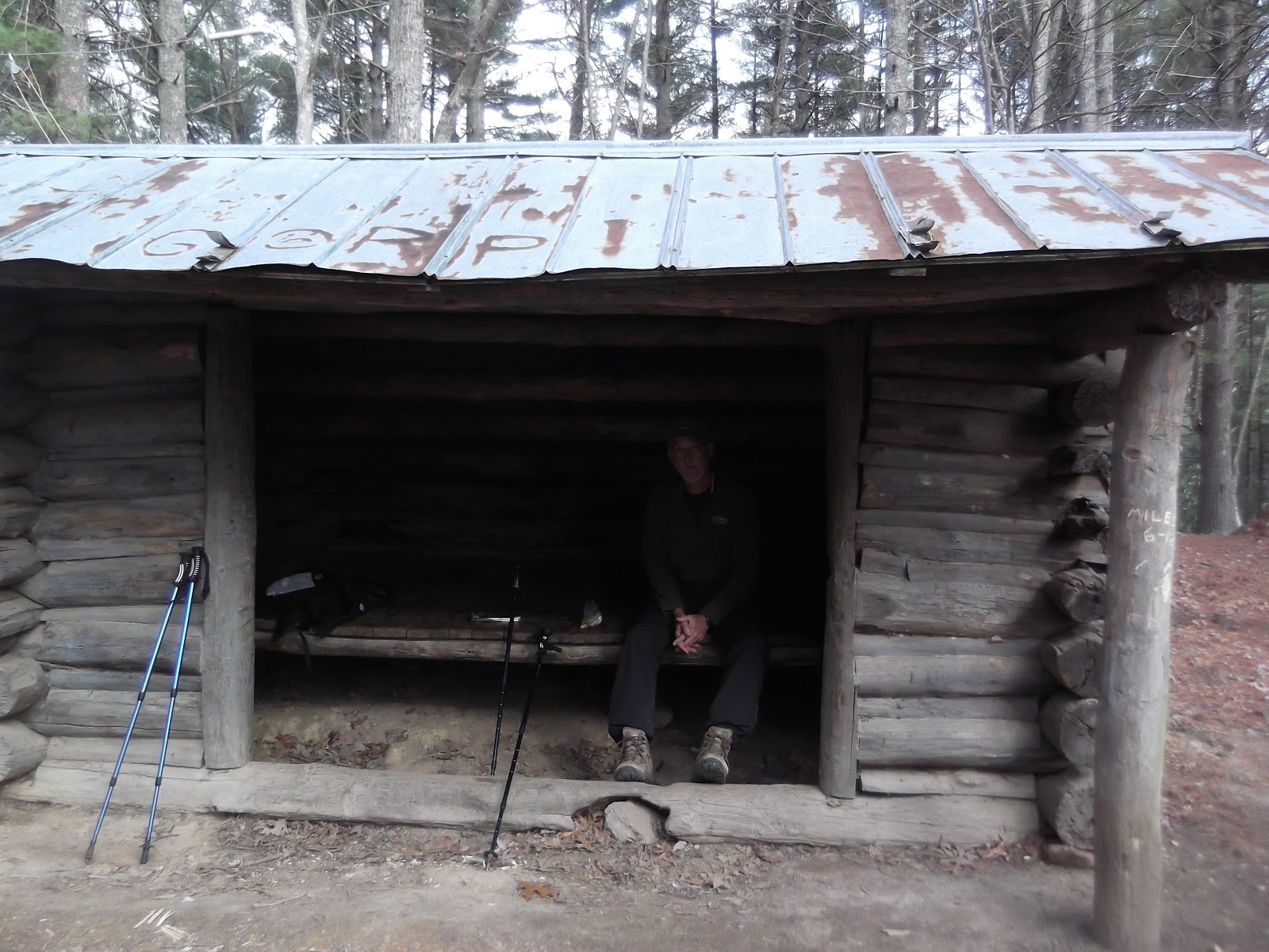
Jerry's Cabin actually had a fireplace.
 
I was at the top of a rocky ledge, Wait-up ws at the bottom.
We climbed up and over rocks like this for several miles.
 
The section past Jerry’s Cabin called Big Firescald Knob is approximately 1.5 miles of very rocky terrain, going up and then down numerous times.  I could not believe some of the climbs that we were required to make, and in the snow I was being extra carelful.  The rocky trail ran right on the peak of the mountain for several miles and we had a view of both the Tennessee side and the North Carolina side.  However, I was so intent on not slipping on the rocks that I forgot to take pictures of the view.  My camera would not work due the batteries being so cold and I was taking pictures with the one phone that we still had battery life on, trying not to run the battery down. 


It was a very hard day.  About 3:30 in the afternoon, we stopped at a spring to refill our water bottles.  While pumping the water through our filter, I looked at Wait-up and he looked at me and I said, “Honey, let’s go home.”  He didn’t hesitate to say “Okay.”   So we made a phone call to our son-in-law and asked him to cancel our plans with Uncle Johnny’s hostel in Erwin for the next two nights.  Unfortunately I had stored the numbers in my phone and not Wait-up’s phone, and my phone was completely dead by this time.  Lesson learned—store the phone numbers of our shuttles and hostels in both phones next time or write them down.

One of the views from
Big Firescald Knob
After a brief stop at Little Laurel Shelter for a snack, it was a very nice and easy 3.3 mile hike on down to Log Cabin Drive.  At 7:30 p.m. we were finished.  We walked back down Log Cabin Drive because, again I could not get the phone number to the hostel from my phone. 

We found out from Hattie that they had rescued three hikers from last night.  One suffered from hypothermia, one with a twisted knee and one with a twisted ankle.  We spoke to the young man with hypothermia in the Hemlock Hollow bunkhouse and his story was that he was spending the night in a shelter and the snow blew in on him, he got up and got his tent and just wrapped it around him, it got condensation in it which turned to ice. When he woke up again he was in bad shape, he called a couple of his hiking buddies who were on another part of the trail to come up and help him down off the mountain.  Whew!  glad that didn't happen to us!

After a farewell to Fred and Hattie at Hemlock Hollow, we were on the road to Knoxville, Tennessee where our daughter and son-in-law are staying right now while looking for a house.  They will be moving there soon.  Maybe we can hike out from there next time as we go through the Smokies. 

I had said that I wanted to be hiking the AT on my 60th birthday.  However, I was just as glad on March 22nd to be waking up warm and snuggly in the Holiday Inn in Knoxville.  We went to breakfast at IHOP with Amber and Ashley, then drove home to beautiful Pace, Florida.

Our total milage on this trip was right at 77 miles in six days of hiking.


Sam's Gap to Big Butt, Southbound

March 20, 2013
Sam’s Gap to Big Butt – Southbound
13.9 miles, 9.5 hours


Fred from Hemlock Hollow shuttled us to Sam’s Gap where we will begin our hike heading south back to Log Cabin Drive.  It will take us two days to travel this section since it is 27.2 miles through it.  We plan to set up camp about half way in. Not long after starting the day, we met a couple about our age from Montana, and their two dogs.  She is a retired school teacher like us.  They started their thru hike on February 28.   She told me her birthday is tomorrow, I told her mine is the day after.  We exchanged blog information, hers is called wegotraveling.blogspot.com

We had some ice on the trail today.  It is still cold, but not as windy so, therefore, overall more comfortable weather.  When you are walking up mountains you tend to warm up pretty well, even if the temperature is cold.

 We passed the twins again and then Jugz.  They appear to be about the same age, but have been missing each other all along the trail.  It looks like Jugz is about to catch up with them;  I hope she finds someone to hike with soon. 

We passed two thru-hikers who had also stayed at Hemlock Hollow along with us last night (Rash and Collin).  They started at Log Cabin Gap where the hostel is and were slack-packing to Devil Fork Gap - I wish we could do that, but we are not yet up to the 19 miles a day mark, so we will have to spend the night in the forest. I hope they make it all the way to Maine - nice guys.

The weather forecast before we left this morning called for snow flurries tonight.  Uh – it became more than snow flurries before the night was over.  We pitched our tent right off the trail somewhere before the summit of Big Butt Mountain.  Not long after we retired for the night, I was just dozing off when I heard a bunch of howling in the distance.  “What’s that?” I asked.  Wait-up said coyotes.  Then I heard something softly hitting the tent.  “Is that snow flurries?” I asked.  We peaked outside and yes, it was snow flurries.  It became harder and harder and every once in awhile the wind would blow furiously.  Before long  we saw that snow was being blown up under our rain fly and we had to hit the side of the tent to knock it off throughout the night.  Sometime in the wee hours of the morning, we both got cold and had to put on more clothes.  Our sleeping bags are rated at zero degrees, but they didn’t keep us warm.  We found out later that the temperature on the mountain got into the single digits. 


A view from the trail.

Along the trail in this section a bob wire fence separates the
states of TN and NC.  You can see it on the right.


Waterfall just before Rector Laurel Road.

Tanyard Gap to Log Cabin Drive, Northbound

March 19, 2013
Tanyard Gap to Log Cabin Drive – Northbound
10.4 miles, 6.5 hours


The cabin at Hemlock Hollow.
 
Mark from Hemlock Hollow shuttled us south to Tanyard Gap where we started our hike going north this time.  There were lots of uphills today.  It was cold and windy all day.  When we were on the east side of the mountain the wind was very chilly.  We met twin girls again today (we have been passing back and forth with them on the trail several times), and found out their names are Kacie and Meagan from Vermont.  They are traveling on pretty fast it seems.  I hope they make it all the way to Maine. 


A beautiful section of the trail through the
rhododendrums thicket.


We passed the 282.8 mile marker of the AT.
We have completed approximately 210 miles of it.


One of the more pleasant sections of the trail

We arrived at Log Cabin Drive around 3:30 in the afternoon and walked the .6 down to the hostel.  We found out later that if we could have called them for a free pickup at the trail.  Oh well.  We stayed the night in the same cabin. 


The trail right on the cliff of the mountain.
 

Garenflo Gap to Hot Springs - Northbound, Tanyard Gap to Hot Springs – Southbound


March 18, 2013
Garenflo Gap to Hot Springs - Northbound, Tanyard Gap to Hot Springs – Southbound
12.5 miles
, 5.5 hours
Moderate

Hot Springs is in the middle of our hike today so we will be going both directions.  Chuck dropped us off again at Garenflo  Gap and we started north.  There were some slight uphills, but mostly downhill from 2500 feet to 1326.  It was windy and a chilly day at 49 degrees, especially on the east side of the mountain. 

We covered the 6.6 miles in 3 hours.
Deer Park Mountain shelter for a short break


The first view of Hot Springs from the trail coming from the South.
 
The AT sign coming into Hot Springs from the south.
 
Back in Hot Springs, it was lunchtime and we again enjoyed the company of Chuck and Tigger for another fine meal at the Smoky Mountain Diner.  The service there is superb, they really know how to cater to the many hikers who come through town. 
We talked with a lone young lady hiker in the diner, named Jugz.  She has come all the way from Springer Mountain hiking alone.  My, what grit!!
Tanyard Gap, the trail passes over the highway overpass.
Looking back at the trail crossing the overpass at Tanyard Gap.
After lunch, Chuck took us north to Tanyard Gap to hike southbound.  The trail crosses over the overpass of U.S. 25 and 70 before going into the forest.  This section is not very high, going from 2270 to 2490, then back down to 1326.  We covered the 5.9 miles in 2.5 hours.  It started to rain just as we were coming back into Hot Springs; we had beaten the rain for most of the trail.


The view of the French Broad River from above.
When you reach the river from the north, you have to climb up to street level and cross over the bridge banister and walk into Hot Springs on the road. 

When we got back to the hostel we met Steven again. He was very discouraged to have everyone tell him he needed to rest his ankle for longer than a day before he continued.  We took him to dinner before we left Hot Springs to try to encourage him and lift his spirits. We left him still undecided about what he was going to do, but we met his friend Zach later on the trail and found out that Steven had decided to take a few weeks  off the trail and catch up with his buddies further north, then come back and complete this section at the end.  
 
It started to rain on us just as we were coming into Hot Springs
from Tanyard Gap.  The only rain we had on this hike.
 
 
Looking back over the French Broad River to the mountains
we hiked on this morning.
Walking into Hot Springs from the north.


We left Hot Springs and drove up to Hemlock Hollow Hostel located on Log Cabin Drive, about .6 mile off the trail.  Hemlock Hollow has a bunkhouse with 8 bunks, two private cabins and a bathhouse. We booked into one of their private cabins.  It had a refrigerator and a microwave.  Usually there is a café also, but it was temporarily closed due to the owner/manager recently having knee surgery.  Fortunately, we had purchased some soup and crackers, oatmeal, Styrofoam bowls and spoons before leaving Hot Springs, so we were able to eat.    


Max Patch to Garenflo Gap – Northbound

March 17, 2013
Max Patch to Garenflo Gap – Northbound
14 miles, 9 hours
Moderate

Tigger took this picture of us
at the top of Max Patch
Tigger is hiking with us today, Yay!  Chuck shuttled us out to Max Patch to head north to Garenflo Gap. I would say it was a moderate day today, rising from a low of 3550 to the top of Bluff Mountain at 4686 then back down to Garenflo at 2500. 
It was great fun having another woman to hike with for a change.  Wait-up went on ahead and left us to talk all we wanted to on the trail.  I guess he enjoyed it too, walking at his own pace instead of waiting on Catch-up at the top of every incline.
Wait-up and Catch-up at the top of Max Patch.
 
Along the way, we met Steven, who had twisted his ankle while sliding down an icy patch in the Smokies.  He said he slipped about 30 feet before he was able to stop.  We heard some gruesome stories from several hikers who had come through the Smokies in February with about three feet of snow on the ground.  Steven would not agree to accept a ride at Garenflo with us nor to let Wait-up carry his pack, but insisted on hiking the entire distance to Hot Springs with his pack.   He made it too after dark that night.  Those thru-hikers are some tuff dudes!
Tigger and Catch-up at the top
of Max Patch
As usual, before the end of the hike Tigger and I started dreaming about a burger, so when Chuck picked us up we headed to the diner.  Unfortunately, the diner closes at 4:00 on Sundays, so we went to the Spring Creek Tavern.  They have a good hamburger too and, I understand, they have a live band on many evenings. 
We had another good night’s sleep in the private room at Laughing Heart.


Wait-up at the top of Bluff Mountain.
 

REST AND RECOVERY DAY IN HOT SPRINGS

March 16, 2013
REST AND RECOVERY DAY
0 Miles

A day off from hiking after only one day of hiking is unusual, I know!  It was not by choice, believe me.  I really didn’t want to do it, but was afraid to take a chance on my symptoms returning while out in the woods, so here we are in Hot Springs for the day.  We couldn’t have landed at a better place for this to happen.  We spent the day walking around the nice little town, visiting a few shops and the diner again, getting to know Chuck Norris and his wife Tigger, visiting with other hikers, and resting.   Solo and Pilgrim are also taking a rest day.  They are an unlikely pair, Solo being from Elijay, GA and Pilgrim from Massachusetts.  It was a good day, and all my symptoms were gone by the end of it.  Ready to get back on the trail tomorrow.

The white blazes of the AT are right in the sidewalk.
 

On the streets of Hot Springs
 

Hot Springs main street
 

Laughing Heart Hostel
 

Max Patch to Waterville School Road – Southbound

March 15, 2013
Max Patch to Waterville School Road – Southbound
13.6 miles, 8 hours


Standing Bear Hostel
This morning we left the Smoky Mountain Best Western Hotel in Waynesville, NC to drive to the Standing Bear Hostel at Waterville School Road.  Curtis has agreed to shuttle us up to Max Patch where we will begin our hike southward back to his hostel where we have left the car. At Standing Bear, I understand they have a bunkhouse, a private cabin and tent sites. 

We arrived at Standing Bear Hostel just before 8:00 a.m. where we met Pilgrim who is working for stay at the hostel.  As it turned out, Pilgrim and his hiking buddy, Solo, joined us on the drive up to Max Patch.  They both commented later how Curtis was rude to us when he was collecting our money for the shuttle drive.  Evidently, it bothered them more than it did us. 

 At 9:00 a.m. we climbed to the summit of Max Patch.  Pilgrim and Solo headed north and we headed south.  We saw them several more times throughout our next few days and got to spend time with them at a hostel in Hot Springs. 

Looking up to the top of Max Patch
The trail in this section (Southbound) drops 1530 feet into Deep Gap, then climbs 1413 feet to Snowbird Mountain before descending 2463 feet again to Waterville School Road.  It sounds like we did more downhills than uphills, but the uphills we did were pretty hard for us, it being our first day back on the trail.  The bad thing about section hiking is that you have to start over on your conditioning each time you go out.  Needless to say, I was tired by the end of 8 hours.
Looking down from Max Patch


The tower at the top of Snowbird Mountain
 
The trail descends to Waterville School Road just south of the Hostel.  It was a short walk up the gravel road to get to our car at the hostel, and we took off to drive up to Hot Springs to spend the night before heading out from there.

The monument at the entrance of Hot Springs
 
On the drive to Hot Springs though, a wave of nausea hit me like I have never had before.  It felt like a severe case of motion sickness, although I have never had car sickness before.  We had to stop the car and let me get some fresh air.  Then I was hit with a fit needing to find a bathroom very quickly.  Luckily we had stopped right at the Tennessee State Line at the State Line Grill and I was able to use their facilities. 

We finally got back on the road and made it to Hot Springs.  Our first stop, of course was the Smoky Mountain Diner for a hamburger.  Wait-up ordered the 8 ounce burger and I ordered a regular, since I was not sure I would keep it down.  It was good food.  The sweet potato fries were awesome!  Then we checked into the Laughing Heart Hostel and were met by the manager, Chuck Norris himself.  We stayed in one of their several private rooms.  They have a couple of bunkrooms as well, three bathrooms, complimentary coffee, and a fully equipped kitchen and TV room for the quests to use.


The Hostel at Laughing Heart Lodge is located right at the foot of the AT as it comes down the mountain into Hot Springs.  It is the first building you will see on the left side of the trail. From the hostel, you can walk down a set of steps to street level to the little town of Hot Springs.  Most of the town can be found in a two-block area.  Some of the most popular places are the Smoky Mountain Diner, Elmer’s Sunnybank Inn, and the Bluff Mountain Outfitters.  The Hostel at Laughing Heart Lodge will soon become a very popular place because of its location and the hospitality you will find there.  It is a new facility, having only one season under its belt.  It opened for business one year ago on March 23, 2012.  It a beautiful piece of property that includes the lodge, a chapel building, and the hostel.  The lodge was formerly a Jesuit monastery and has been beautifully remodeled into a modern-day place of lodging, retreats, and healing.  And indeed, it was a place of healing for me.  During the night, I was again hit with a bad case of various stomach maladies and had to take the next day off from hiking to recover.  I can’t say enough good things about the hostel at Laughing Heart Lodge, you will have to find out for yourself or visit their webpage at http://www.laughingheartlodge.com/index.php/accommodations/hostel/
Note about Elmer's - I called from the top of Snowbird mountain to book a room there for the night, but found out that they charge more for section hikers than for thru-hikers, so I opted to stay at Laughing Heart.  However, I have read about Elmer's on other blogs and know that it is a very nice place--a historic house with excellent meals and the host has been very gracious to hikers for many years.  His hospitality is appreciated by the thru-hikers.


Elmer's Sunnybank Inn
 

The Smoky Mountain Diner in Hot Springs,
wonderful food and good service


NORTH CAROLINA/TENNESSEE BORDER

Well!  We finally made it to the AT again!  Long time since we planned to go to the GSMNP last July.  This time we decided to skip the SMNP and begin our hike north of it (for several reasons). 

With my 60th birthday coming up, I had a crazy hankering to spend it on the AT.  So on Thursday, March 14, we drove north to Waynesville, NC to spend the night before beginning our hike the next day.

We have been in training for 8 weeks before this hike, using our wonderful "walking around the soccer field, up and down the bleachers, up and down the hill from the creek" method.  We will see if it keeps us from getting sore this time. 

We will be "slackpacking" most of this trip.  That means we will be spending the night at various hostels along the way and taking only a daypack with us out on the trail each day.  There is only one section that is too long without road access to allow us to do this.  So we will have one night in the tent on the trail, not even at a shelter.

Keep reading for a day by day progress report of our hike.