Showing posts with label Rutherford Shelter. Show all posts

Rutherford Shelter to Lott Road


Day Four
Thursday, September 29, 2016
Rutherford Shelter to Lott Road
11.7 miles

It rained again last night with cold wind blowing, flapping the sides of the tarp.  I dreamt that a bear was standing at my side of the tent and hitting it with his paw.  I could see his silhouette very clearly.    I awoke myself and Wait-up trying to scream. 

Although it was a short day today, it was hard for us.  The first part of the day was rocks, rocks, and more rocks.  Rocks are getting really old, we are not getting much sleep, and we both have blisters.


Observation Tower
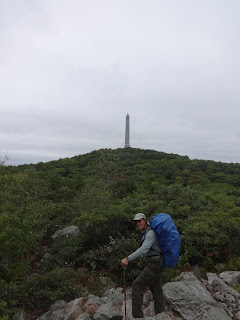
High Point Monument
 
 
High Point Monument
At High Point State Park office the kind lady gave us a cup of coffee.  We have been missing our hot coffee in the mornings because we chose not to bring our stove with us in order to save weight since we have to carry more water.  And since it is cold and wet, the coffee was a very welcomed treat.  She also offered us a complimentary Pepsi, provided by a friends of hikers group in the area to thru-hikers.  She said we qualified, since we are doing a long section.  Another thru-hiker came in and she made him the same offer and he said, “Can I have both?”  Huh, we hadn’t thought of that.  Wish we had. 

We saw and took pictures of High Point Monument, the highest point in the state of New Jersey at 1803 feet. 

Between High Point State Park and Lott Road, it seemed like we were crossing a road every few minutes, 8 of them within 8 miles. 

The last 3 or 4 miles before Lott Road, we finally got out of so many rocks and found rolling pasturelands and boardwalks.  Still, it was a long 4 miles before we reached town and we were again exhausted.  We reached Lott Road or Jersey Avenue and walked .4 downhill into Unionville, New York. Local folks will know that although we are hiking New Jersey, almost immediately when you leave the trail and head toward town, you enter New York.  The A.T. is right on the borderline for several miles in this area.


We had planned to resupply in Unionville at Horler’s Store and camp in the Unionville Memorial Park where we had read that we could get a cold shower.  Although I was not looking forward to a cold shower, I thought it would be at least enclosed.  No, the lady in the store told us it was a water hose outside.  Oh my! 

As we sat on the front porch of Horler’s weighing our options, talking to the store employees and several customers about places to stay in the area, we had the good fortune of one of the store clerk’s offering to take us to a Day’s Inn about 15 minutes away in Montague (or Port Jervis).  We don’t know how will get back, but right now we just wanted to get there and take a day off tomorrow.  Wait-up needs to get some sinus medication, we need to treat our blisters, and we need to rest.  We’ll worry about getting back when the time comes. 

So Kelly drove us to Day’s Inn.  We ordered pizza delivery then walked down a hill to Shop-Rite to get medicine and resupply.  While in line at the check-out, the lady in front of me started talking to me and found out we were hikers staying at Day’s Inn.  She offered to drive us back up the hill.  Score!  Two trail angels in one day!  God is good. 

Brink Shelter to Rutherford Shelter

Day Three
Wednesday, September 28, 2016
Brink Shelter to Rutherford Shelter
14 miles

 
We arose and quickly got on our way, as we were planning to hike about three miles then have breakfast at Gyp’s Tavern or Sunrise Appalachian Trail Deli in Branchville.  They are supposed to be right on the trail.  When we got to the deli there was a sign on the door saying it was temporarily closed and recommended we go to Gyp's Tavern right down the road.  Our hiker’s companion said Gyp's opened at 9:00 a.m., and we would be just in time.  HOWEVER, when we got there, there was not a soul to be seen.  They were not opened.  We went next door to a Sport’s Shop and asked them, they said Gyp’s opened at 11:00.  We quickly surveyed the place and found the only thing they had to offer us was a soda, which we took advantage of, but that’s not breakfast.  We asked about other restaurants and they said there was one about a mile the other direction.  We asked about a local taxi service (not wanting to walk an extra two miles) and were told that the closest taxi charges $40 just to come here.  Oh well, we sat on a rock outside and ate a Clif Bar along with our soda.  What a disappointment.  But this is not the only time we will be disappointed on this trip, expecting a deli and the deli being closed. 
Gyp's Tavern
Gyp's Tavern


We filled our water bottle from their restroom and got back on the trail.


We saw a small card on a tree advertising a new hostel in the area.  I took a picture of it just in case we needed it.  It said he/she was a former thru-hiker and would pick up at High Point State Park.  We later tried to call the number to see if we could get a ride from Unionville and did not get an answer. 
As we climbed to the top of Sunrise Mountain, we suddenly found ourselves on the top looking at a pavilion.  It seemed so out of place from this side, but we found out that there was a parking lot not too far from it on the other side.  Several men loitered around the shelter, looking at the view.  I remembered reading in Jennifer Pharr Davis's book, "Becoming Odyssa" that she had come upon a hanging victim on Sunrise Mountain at a pavilion and realized that this was the very location. 
Sunrise Mountain Pavilion
View from Sunrise Mountain


At Mashipacong Shelter we again found water in a 5-gallon jug.  Luckily we didn’t need any.  We trudged on, planning to stay at Rutherford Shelter.  Finding that it was .4 off the trail, we set up a stealth camp instead.  In fact, we didn’t stay in a single shelter this whole trip.